The shift to car-free cities isn’t about banning vehicles; it’s about redesigning the entire mobility ecosystem to be so efficient and responsive that private cars become obsolete by choice.
- Traffic isn’t just an inconvenience; it’s a multi-billion-dollar drain on productivity that requires a systemic, not piecemeal, solution.
- The future lies in orchestrating all modes of transport—from trains to e-scooters—into a single, data-driven network that actively shapes travel demand.
Recommendation: Urban planners and citizens should focus on promoting integrated Mobility-as-a-Service (MaaS) platforms and public-private data partnerships as the foundational step toward a more livable and efficient city.
The daily grind of traffic, the endless search for parking, the blanket of smog hanging over the skyline—these are the shared frustrations of modern urban life. For decades, the proposed solutions have been predictable: build more roads, add more bus lines, or paint a few more bike lanes. While well-intentioned, these measures often treat the symptoms rather than the underlying disease: a transportation grid designed around the single-occupancy vehicle, an artifact of the 20th century struggling to serve the dynamic needs of the 21st.
But what if the true path to a more livable, efficient, and equitable city isn’t just about adding more options, but about fundamentally rethinking the system itself? A new vision is emerging, one that moves beyond simply managing congestion to actively orchestrating a responsive, data-driven ecosystem of transport. This approach sees the urban grid not as a static collection of roads and rails, but as a dynamic tool for enhancing civic well-being. It’s a paradigm shift from accommodating cars to prioritizing people, enabled by technology that can understand and shape how, when, and why we move.
This article explores the blueprint for this transformation. We will dissect the true cost of our current model, analyze the strategies for seamless multimodal travel, compare foundational infrastructure choices, and reveal how innovative solutions are creating a grid that is intelligent, adaptable, and ultimately, human-centric. It’s a journey into the future of urban mobility—a future that is already taking shape.
text
For those who prefer a visual format, the following video offers a compelling immersion into the aesthetics and atmosphere of cities that have already embraced car-free designs, perfectly complementing the strategic insights of this guide.
To fully grasp the components of this urban evolution, this guide is structured to walk you through each critical layer of the new mobility ecosystem. The following sections detail the problems we face, the solutions at our disposal, and the visionary thinking required to build the cities of tomorrow.
Summary: A Blueprint for the Post-Car Metropolis
- Why Traffic Congestion Is Costing Your City Billions in Lost Productivity?
- How to Commute Using Train and Bike Without Being Late?
- Underground Metro vs. Light Rail: Which Solves Density Problems Better?
- The Deferred Maintenance Mistake That Leads to Bridge Failures
- When to Travel to Avoid the “Super-Peak” Hour in Major Cities?
- Main Road vs. Side Streets: Which Walking Route Exposes You to Less Gas?
- Why Not Tracking Your Fleet Is Costing You More Than the Software Subscription?
- Innovative Mobility Solutions: Are E-Scooters a Fad or the Future of Transport?
Why Traffic Congestion Is Costing Your City Billions in Lost Productivity?
Traffic congestion is more than a daily annoyance; it is a profound economic hemorrhage draining the vitality of our cities. The sheer scale of this loss is staggering. In the United States alone, traffic delays result in $70.4 billion lost annually, with a single metropolis like New York City absorbing over $9 billion of that cost. This isn’t just about the fuel wasted in gridlock or the value of lost time for individual commuters. It represents a massive brake on overall economic productivity, impacting supply chains, service delivery, and access to labor.
The very nature of this congestion is also evolving. The traditional model of a sharp morning and evening “rush hour” is dissolving. As Bob Pishue, a leading transportation analyst, notes, the pattern is changing: “Instead of a morning peak, then a midday peak, and an afternoon peak, the congestion is much more gradually building throughout the day. That’s huge because it has planning implications.” This shift, driven by hybrid work and more flexible schedules, means that simple solutions like adding a lane to a highway are no longer effective. The problem has become a chronic, all-day condition that requires a more sophisticated, systemic response.
This constant, low-grade fever of congestion puts continuous stress on our civic infrastructure, increasing wear and tear and driving up maintenance costs. It also creates a negative feedback loop: as driving becomes more unpredictable, people allocate even more buffer time for travel, further bloating the number of vehicles on the road at any given moment. To break this cycle, cities must move beyond accommodating traffic and start actively managing the entire mobility ecosystem to reclaim those lost billions and reinvest them in a more productive, livable future.
How to Commute Using Train and Bike Without Being Late?
The secret to a reliable multimodal commute isn’t about frantically pedaling faster or sprinting for the train; it’s about a fundamental mindset shift from seeking the “fastest route” to designing the “most reliable journey.” This is the core principle of journey orchestration, a cornerstone of modern urban mobility. It involves building predictable time buffers into your plan and leveraging a connected ecosystem of transport options that work in concert to eliminate uncertainty.
At the heart of this revolution are Mobility-as-a-Service (MaaS) platforms. These are not just map apps; they are powerful integrators that provide real-time data on disruptions, suggest intelligent alternative routes, and unify payment across different modes. The scale of this transformation is immense, with the European MaaS market alone projected to reach a market value of €228.6 billion in 2024. This demonstrates a massive public and private investment in creating a seamless travel experience.
Effective journey orchestration relies on intelligent infrastructure at key connection points. This includes first-mile/last-mile mobility hubs at train stations, offering secure bike parking and effortless bike-share integration. By transforming transit time from “lost time” to productive or relaxing time, the entire perception of the commute changes. A journey spent reading on a train or listening to a podcast while cycling through a park is no longer a stressful necessity but a valuable part of the day. The goal is to make the combination of a train and a bike not just a sustainable choice, but the most logical, predictable, and pleasant one available.
Underground Metro vs. Light Rail: Which Solves Density Problems Better?
When a city commits to high-capacity public transit, a fundamental choice emerges: to build down into the earth with an underground metro or to weave through the urban fabric with a surface-level light rail. This decision has profound implications for a city’s density, character, and future growth. There is no single correct answer; the optimal choice depends entirely on a city’s unique geography, density patterns, and long-term vision. The metro is the champion of speed and capacity, a solution that operates on a completely separate grade, immune to the surface world’s traffic and congestion. By tunneling beneath the city, it can move vast numbers of people quickly over long distances, making it ideal for connecting a sprawling, polycentric metropolis. However, this power comes at a tremendous cost, both in terms of initial capital investment and construction disruption.
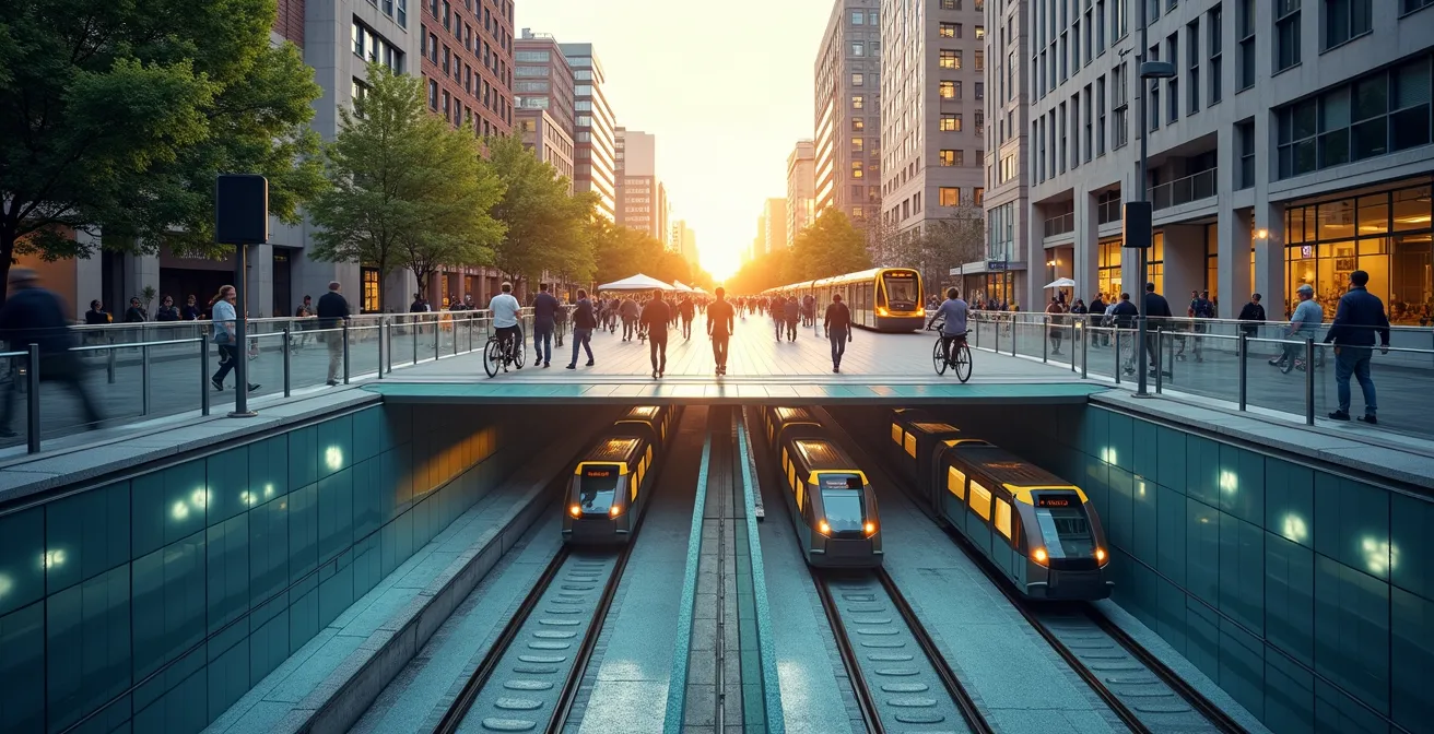
As the visualization above illustrates, light rail offers a different proposition. It is a tool of urban acupuncture, more intimately integrated with the streetscape. It is significantly less expensive to build and can be implemented more flexibly, revitalizing corridors and stimulating street-level economic activity. Its limitation, however, is its co-existence with other traffic. While often given dedicated lanes, it remains susceptible to intersections and surface-level disruptions, making it better suited for connecting dense, nearby neighborhoods rather than entire regions. The choice is strategic: a metro system bypasses density, while a light rail system serves and shapes it. Visionary urban planning often involves a hybrid approach, using a metro for the city’s primary arteries and light rail to feed and distribute from it, creating a multi-layered and robust mobility ecosystem.
The Deferred Maintenance Mistake That Leads to Bridge Failures
For decades, urban infrastructure has been managed under a reactive paradigm: build, wait for it to degrade, then pay a premium for emergency repairs. This cycle of “deferred maintenance” is a ticking time bomb, particularly for critical assets like bridges, which are subjected to relentless stress from heavy vehicle traffic. The result is not only a massive financial liability but a catastrophic risk to public safety. Each vehicle, especially heavy freight trucks, contributes microscopic damage that accumulates over time, and the sheer volume of traffic in congested cities accelerates this decay exponentially. The deferred maintenance mistake is assuming that our infrastructure can indefinitely absorb this punishment.
A visionary approach to urban design flips this script entirely. Instead of merely planning for the eventual repair of over-stressed assets, it focuses on redesigning the urban grid to fundamentally reduce the sources of that stress. The goal shifts from infrastructure preservation to proactive demand management. This is a core element of treating our transportation network as true civic infrastructure—an asset to be nurtured for long-term health, not just used until it breaks.
Cities like Barcelona provide a powerful case study. By implementing its “superblock” model, the city has strategically reclaimed streets from cars, reducing overall traffic by 25%. This isn’t just an environmental or aesthetic victory; it is a profound infrastructure strategy. By calming traffic and redirecting flows, Barcelona has dramatically lowered the daily stress on its roads, bridges, and underground utilities. This proactive redesign extends the life of existing assets, frees up billions in future repair costs, and creates a more resilient and sustainable urban form. It proves that the most effective maintenance plan is one that begins with designing a system that requires less maintenance in the first place.
When to Travel to Avoid the “Super-Peak” Hour in Major Cities?
The concept of a singular “super-peak” hour is rapidly becoming obsolete. The rise of hybrid work has fundamentally reshaped urban travel patterns, flattening the traditional morning and evening spikes and creating a more sustained, all-day flow of movement. Recent data reveals a 23% increase in midday trips since 2019, reflecting a new “10-to-4” work culture. This means the question is no longer “when to travel to avoid the peak,” but rather “how can the city as a whole shape demand to avoid peaks from forming at all?”
This challenge requires a strategy of demand shaping—using a combination of policy and technology to distribute travel more evenly throughout the day. Instead of passively reacting to congestion, cities can actively influence it. This involves a multi-pronged approach that goes far beyond just building more infrastructure. It’s about intelligently managing the flow on the existing grid, much like a conductor orchestrates an orchestra to create a harmonious sound rather than a cacophony of noise.
Implementing these strategies turns the entire city into a responsive grid, optimizing itself for efficiency and livability. The goal is to make the most efficient travel time the most convenient and affordable, creating a virtuous cycle where the system balances itself. The “super-peak” becomes a relic of the past, not because it was avoided, but because it was designed out of existence.
Action Plan: System-Level Strategies for Peak Hour Reduction
- Policy Levers: Implement and encourage flexible work policies and remote work as the primary ‘peak-shaving’ tools to reduce commuter density.
- Incentivization: Introduce dynamic pricing for public transport and tolls, making off-peak travel financially more attractive for citizens and businesses.
- Schedule Staggering: Coordinate with school districts and large employers to stagger start and end times, breaking up the concentrated morning and afternoon rushes.
- Logistics Optimization: Mandate off-hour delivery windows for commercial and freight vehicles to remove heavy trucks from the grid during passenger-heavy periods.
- Predictive Technology: Deploy AI-powered traffic management systems that can predict emerging congestion and proactively reroute traffic flows across the network.
Main Road vs. Side Streets: Which Walking Route Exposes You to Less Gas?
The choice of a walking route is often seen as a simple matter of distance or habit. Yet, in the context of a modern city, it’s a critical public health decision made dozens of time a day. Main arterial roads, designed to maximize vehicle throughput, function as canyons of concentrated air and noise pollution. Walking along these corridors exposes pedestrians to significantly higher levels of harmful emissions, including nitrogen dioxide (NO₂) and particulate matter, directly impacting respiratory health.
Choosing a route through a network of quieter side streets, even if it adds a few minutes to the journey, can drastically reduce this exposure. This is where urban design becomes a form of preventative medicine. By creating a “permeable grid” of safe, pleasant, and well-connected pedestrian pathways away from major traffic arteries, cities can actively guide people toward healthier choices. This isn’t about forbidding access to main roads but making the alternative so superior that it becomes the natural option.
The impact of such design is not theoretical. In Barcelona, the implementation of superblocks—which prioritize pedestrian and local traffic on interior streets—led to a remarkable 25% decrease in ambient nitrogen dioxide levels within those zones. This proves that reconfiguring the street grid is one of the most powerful tools a city has to improve air quality and public health. Every side street transformed into a green, quiet, and safe walkway becomes a new artery for community health, offering a clear path away from the toxic legacy of car-centric design.
Why Not Tracking Your Fleet Is Costing You More Than the Software Subscription?
For a logistics company, the cost of not tracking its fleet appears on the balance sheet as wasted fuel, excess overtime, and inefficient routing. For a city, the cost is far greater. Untracked and unoptimized commercial fleets are a major contributor to the urban congestion that imposes a staggering $74.1 billion annual cost on the U.S. freight sector alone. These vehicles idle in traffic, double-park on crucial arteries, and make deliveries during peak hours, creating bottlenecks that ripple through the entire system.
Modern fleet tracking is about far more than a dot on a map. It is the key to unlocking a responsive grid. When fleet data is anonymized and shared through public-private partnerships, it becomes an invaluable resource for urban planners. This data can be used to optimize traffic signal timing in real-time, identify chronic double-parking hotspots that need redesigned loading zones, and inform dynamic pricing strategies for commercial vehicle access to the city center. The software subscription, in this context, is a small investment for access to a data stream that can help manage the entire urban logistics ecosystem.
Furthermore, this data empowers transformative strategies like logistics pooling, where multiple companies share vehicle space for last-mile deliveries, drastically reducing the number of trucks in dense urban cores. It also provides the strategic insight needed to plan the transition to electric fleets, identifying optimal routes and charging infrastructure locations. By failing to embrace this technology, companies are not just hurting their own bottom line; they are withholding the very data that cities need to build a cleaner, more efficient, and less congested future for everyone.
Key Takeaways
- The true cost of car-centric urban design is measured in billions of dollars of lost productivity and immense, ongoing stress to civic infrastructure.
- The future of mobility is not about a single solution, but about orchestrating an integrated ecosystem of transport modes into a seamless, reliable journey experience.
- Data is the most critical asset for the modern city, enabling a responsive grid that can actively shape travel demand, optimize logistics, and improve public health.
Innovative Mobility Solutions: Are E-Scooters a Fad or the Future of Transport?
Dismissing e-scooters and other forms of micromobility as a mere fad is to miss their profound strategic importance in the new urban mobility ecosystem. These small, electric vehicles are not replacements for trains or buses; they are the missing connective tissue. They solve the critical “first-mile/last-mile” problem—the gap between a transit stop and a final destination that so often pushes commuters back into their cars. The potential impact is transformative; one study found that with effective e-scooter integration, access to public transit within a major urban area could leap from 23.9% of the population to an incredible 97.9%.
But the value of e-scooters goes far beyond simple convenience. As urban mobility researchers have pointed out, they function as powerful data-gathering tools, “revealing how people actually want to move.” Every trip taken on an e-scooter traces a “desire line”—a direct path that often exposes flaws in the existing street design. This data is an invaluable, real-time map of user needs, showing planners exactly where a new protected bike lane is most needed, where a crosswalk is missing, or where a path is inconvenient. They are, in effect, a constant, crowd-sourced audit of the urban grid.
E-scooters are a vital component of a resilient, multi-layered mobility network. They provide a flexible, low-cost, and low-emission option that perfectly complements high-capacity mass transit. As cities like Amsterdam integrate e-bikes and other shared mobility into their comprehensive MaaS platforms, they demonstrate that the future isn’t about choosing one mode over another. It’s about providing a rich menu of options and orchestrating them into an intelligent system that makes the most efficient choice the easiest choice. In this context, the e-scooter is not a fad; it’s a fundamental piece of the puzzle for building a more responsive, human-centric city.
The journey toward a post-car city is a complex but necessary evolution. By embracing a systemic, data-driven approach, urban planners and engaged citizens can co-create a future that is more efficient, equitable, and livable. The next logical step is to champion the development and adoption of integrated MaaS platforms within your own community, fostering the public-private partnerships that form the bedrock of a truly responsive urban grid.